

The National Weather Service has issued a Flash Flood Watch in effect for our area through late tonight. They report:
Showers and thunderstorms producing heavy downpours will develop this morning and continue through tonight. The trend appears for there to be one round early this morning, followed by a potential lull in the heavy rain from late morning through early afternoon. Another round of slow moving showers and thunderstorms will develop this afternoon through this evening. Although rainfall amounts area wide will generally average less than one inch, there is the potential for locally heavy rainfall of 2 to 3 inches, possibly more, where thunderstorms train over the same location.
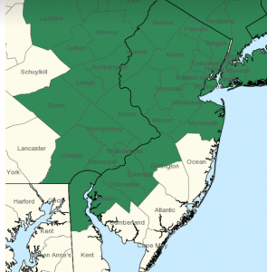
The areas in dark green on the map below show potential flash flooding;
Heavy rainfall within a short period of time can lead to rapidly rising water and flash flooding, particularly in urban areas, and along small creeks and streams. The ground remains fairly saturated due to recent heavy rains over the past several weeks.
A Flash Flood Watch means that there is the potential for flash flooding which can be life-threatening. Heavy rain is expected to occur over a short period of time. Rapidly rising flood waters may quickly inundate roadways and areas of poor drainage. Streams and creeks could leave their banks, flooding nearby properties.